
Projects and files
This chapter explains the .terrace project file and how Terrace opens, saves, exports and autosaves your work, including DWG and DXF. It ends with Project Settings, where you set the units, the coordinate system, how stations and angles read, and the project information your sheets and reports print.
The .terrace project file
A Terrace project is one file ending in .terrace. It keeps everything: the drawing, every civil object with what it's built from, the project settings, the standards and styles, and the layouts with your sheets.
Inside, it's an ordinary DXF file (AutoCAD 2018 format) with the civil data added after the drawing. That has a useful side effect:
Tip Rename a copy of a .terrace file to .dxf and it opens in any CAD program, showing the plan, the profile views, the labels and the sheets as plain lines and text — like Civil 3D's "export to AutoCAD". Your client can open it without Terrace. Terrace itself still recognizes the file by its contents and opens it as a full project.
The file starts with a short header saying it's a Terrace project, which version of Terrace saved it and when, and the project's name. If a file was cut short, or was saved by a newer Terrace, opening it says so in plain words instead of failing silently.
New and open
| To | Use |
|---|---|
| Start a project | File ▸ New Project (⌘N), File ▸ New Project With ▸ DPWH (metric) / AASHTO (metric) / AASHTO (US feet), the + after the drawing tabs, or the start page |
| Start a plain drawing | File ▸ New Drawing or Blank Drawing on the start page |
| Open a file | File ▸ Open… (⌘O), Output ▸ Open Drawing, or drag it onto the window |
| Open a recent file | File ▸ Open Recent (the last ten; Clear Menu empties it), or Recent Documents on the start page |
| Close | File ▸ Close (⌘W) or the × on the drawing tab |
What Open… does depends on the file:
.terraceopens as a project on the Survey tab. The command line says what's in it: Opened road.terrace: 9 civil objects, 49 points, 532 drawing objects..dwg/.dxfopens as a drawing on the Draft tab, with its layers, blocks, layouts and references. Things the file had that Terrace can't show are listed in a yellow bar under the tabs (Show All, Dismiss)..xml(LandXML) isn't opened as a drawing: it's imported into the current project — or a new one if none is open — through the LandXML import dialog, where you choose what to bring in. See Importing and exporting.
Files over about 3 MB open in the background, with a card saying Opening …, so the window stays responsive. A file that's already open just comes to the front.
Saving
- Press ⌘S (File ▸ Save).
- The first time, a new project goes straight to the Save Project As file dialog: choose a folder and a name.
- The command line confirms: Saved Teresa Bypass.terrace (Terrace Project, 8023 KB), with how long it took. The * on the tab goes away, and the file joins Open Recent.

.terrace.When you close a tab or quit with unsaved changes, Terrace asks Save changes to …? with Don't Save, Cancel and Save. Quitting asks about each drawing in turn.
Save As, and DWG / DXF
File ▸ Save As… (⇧⌘S, also Output ▸ Save As and Sheets ▸ DWG / DXF) first asks for the file type, then for the file.
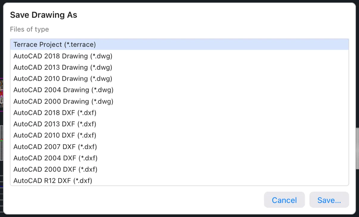
| You choose | For a project | For a plain drawing |
|---|---|---|
| Terrace Project (*.terrace) | Saves the project under a new name (Save Project As). | Turns it into a project file. |
| A DWG (AutoCAD 2000 to 2018) or DXF (R12 to 2018) version | Exports the plan as a plain drawing (Export Drawing): civil objects become ordinary lines, arcs and text. The project stays a .terrace file and stays open as it was; the command line says Exported the plan as a plain drawing to …; the project stays …. | Saves it in that format and version; the tab now follows the new file. |
Older versions can't keep everything (gradients before AutoCAD 2004, for example); Terrace lists what was left out on the command line, starting Not kept in …, and in the yellow bar under the tabs. Terrace remembers the last DWG/DXF version you chose for plain drawings.
Note Only .terrace keeps the civil objects editable. A DWG or DXF is for sharing the drawing. For sharing the design data itself with Civil 3D and other civil software, use LandXML (Sheets ▸ LandXML); see Importing and exporting.
Autosave
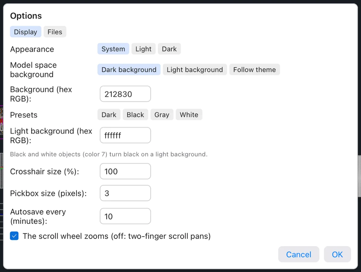
Terrace keeps a safety copy of your work while you work. Every few minutes, each open drawing that changed since its last copy is written to the autosave folder in Terrace's data folder — on a Mac, ~/Library/Application Support/dev.syncster.terrace/autosave. A project is kept whole, as name.sv$.terrace; a plain drawing as name.sv$.dwg. Your own files are never touched by autosave.
- Set how often in Terrace ▸ Settings… (⌘,) or Output ▸ Options, field Autosave every (minutes). The default is 10;
0turns it off. - To get work back after a crash, open the
.sv$.terracefile with File ▸ Open… and save it under a proper name.
Drag and drop
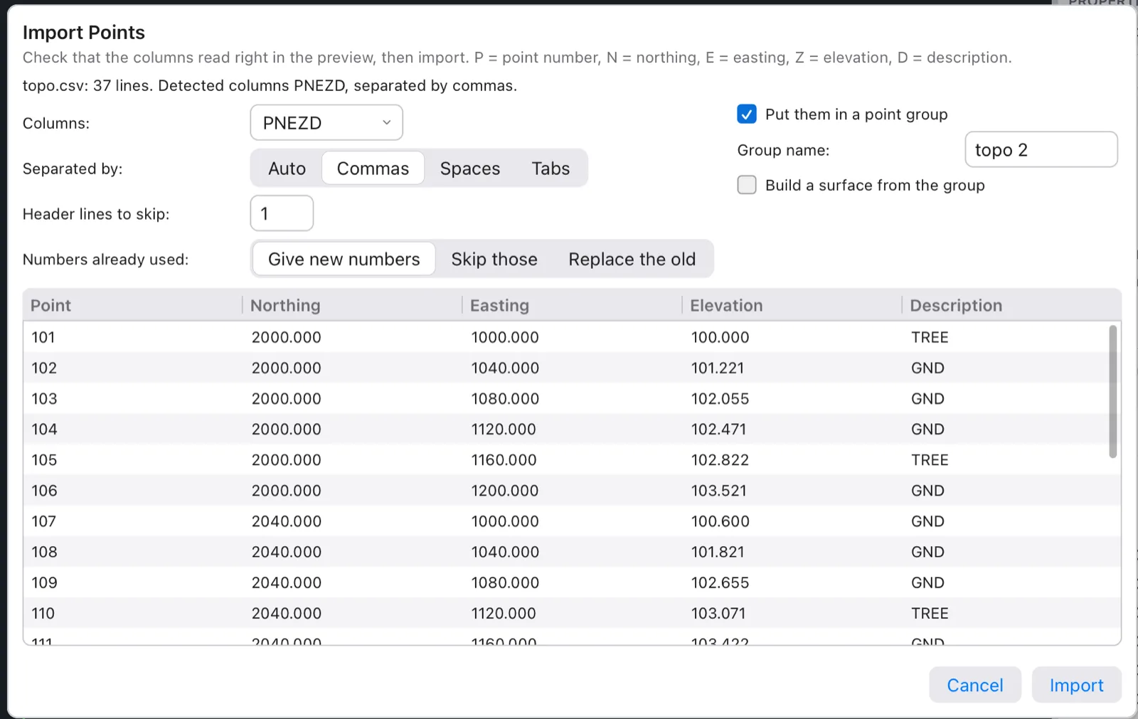
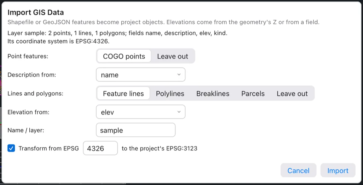
Drop a file anywhere on the Terrace window. Every survey and GIS file that one of the import dialogs reads opens that dialog, into the current project (or a new one if a plain drawing or nothing is open), and the command line says Importing …: choose what to bring in.
| Files | What happens |
|---|---|
.terrace, .dwg, .dxf | Opened, as with File ▸ Open… |
.xml (LandXML) | The LandXML import dialog |
Point files: .csv, .txt, .pnt, .nez, .pnezd, .xyz | The Import Points dialog |
Raw survey data: .rw5, .sdr, .gsi | The raw data import dialog |
Point clouds: .las, .laz | The point cloud import dialog |
Elevation grids: .tif, .tiff, .asc | The elevation grid import dialog |
GIS files: .shp, .geojson, .json, .kml, .kmz | The Import GIS Data dialog. KML and KMZ are read as WGS 84 latitude/longitude (EPSG:4326), and the dialog offers to transform them to the project's coordinate system. |
.png, .jpg, .jpeg | Attaches the image to the drawing (needs an open drawing) |
.scr | Runs the script file |
Anything else gets the notice Terrace opens .terrace projects, LandXML (.xml), .dwg and .dxf files; a file of an importable type that can't be read gets Terrace can't import ….
Project Settings
Project Settings decides how this project measures and labels things. Every label in the drawing and every report follows it, so set it at the start of a job — though you can change it any time, and everything is redrawn.
Open it from any of these:
- Survey ▸ Project Settings or Sheets ▸ Project Settings
- Terrace ▸ Project Settings… in the menu bar
- The gear next to the project's name at the top of the Project browser
- ⌘K and type
settings
The dialog has three pages: Units & coordinates, Formats and Project info. Switch pages freely; nothing changes until you click OK. Cancel or Esc closes it without saving.
Units & coordinates
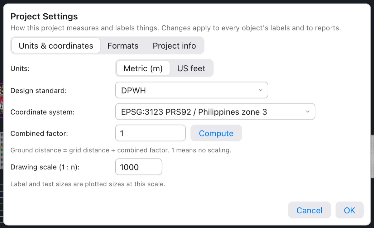
| Field | What it means |
|---|---|
| Units | Metric (m) or US feet. Numbers already in the project are not converted; Terrace warns you in orange when you change it. Use it only to fix a project started with the wrong units. |
| Design standard | Which of the project's standards (DPWH, AASHTO…) new objects and design checks use. Edit the tables in Standards and styles. |
| Coordinate system | None (local coordinates), or a system by its EPSG code: PRS92 / Philippines zones, Luzon 1911 zones, WGS 84 / UTM zones, and latitude/longitude. Imports and exports of geographic data use it, and so does the combined factor. |
| Combined factor | The grid-to-ground factor: ground distance = grid distance ÷ combined factor; 1 means no scaling. It must be a number near 1 (between 0.5 and 1.5). Compute works it out for the middle of the project (from the points, else the surfaces, else the alignments) and its typical elevation, and shows the scale factor and the elevation factor that make it up. It needs a projected coordinate system, not latitude/longitude. |
| Drawing scale (1 : n) | The plot scale, such as 1000 for 1:1000. Label and text sizes in styles are plotted sizes at this scale. |
The COORDINATESYSTEM command (CRS, EPSG; Survey ▸ Coordinate System) sets the same two things on the command line: it asks for an EPSG code (List prints the codes, None goes back to local coordinates), then for the combined factor. See Survey and points.
Formats
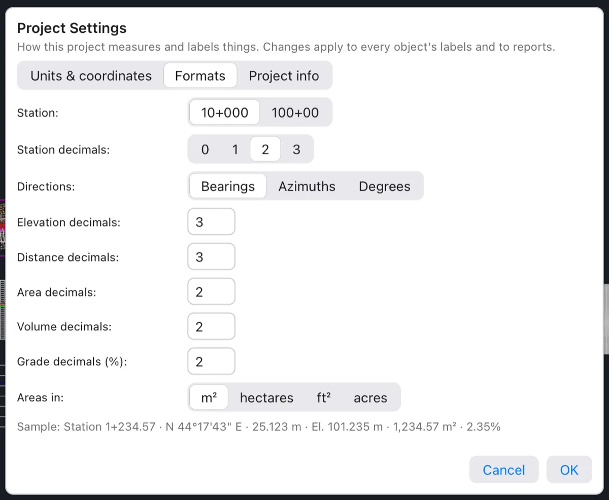
| Field | Choices |
|---|---|
| Station | 10+000 (kilometre stations, as DPWH writes them: 35+200) or 100+00 (100-foot stations) |
| Station decimals | 0, 1, 2 or 3 |
| Directions | Bearings (N 44°17'43" E), Azimuths or Degrees |
| Elevation, Distance, Area, Volume, Grade decimals (%) | 0 to 8 decimal places each; other values are ignored |
| Areas in | m², hectares, ft² or acres |
The Sample line at the bottom updates as you change things, so you can see how a station, a direction, a distance, an elevation, an area and a grade will read before you click OK.
Note Technical descriptions of parcels write bearings their own way, "N. 08 deg. 14' W.", whatever is chosen here. See Parcels.
Project info
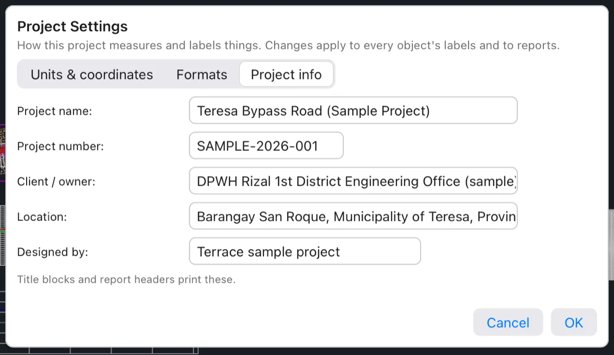
Fill in Project name, Project number, Client / owner, Location and Designed by. Title blocks on sheets and the headers of reports print them, and the project name appears at the top of the Project browser.
When you click OK
Terrace checks the combined factor and the drawing scale (The combined factor must be a number near 1 (like 0.99995)., The drawing scale must be a number above 0 (1000 for 1:1000).), then saves the settings, redraws every civil object so its labels follow the new formats and scale, and says Project settings saved. It's one undo step, named Project Settings in the undo history.
Note Project Settings is separate from Format ▸ Units… (UNITS), the drafting dialog for how plain drawing lengths and angles display. See Drafting.