Terrace
Terrace's icon: a ground profile cut into three terraces, with a curving road above it, in white on green Civil engineering design · macOS and Windows

Design the road.
Everything else follows.

Terrace is civil design software for the whole job: survey and COGO, terrain surfaces, alignments and profiles, corridors, cross sections and earthwork, grading, storm drains and water mains, parcels with technical descriptions, plan-and-profile sheets and reports. DPWH and AASHTO standards are built in, and it is made to be easier to use: a guided workflow, one plain panel per object, and live linked editing.

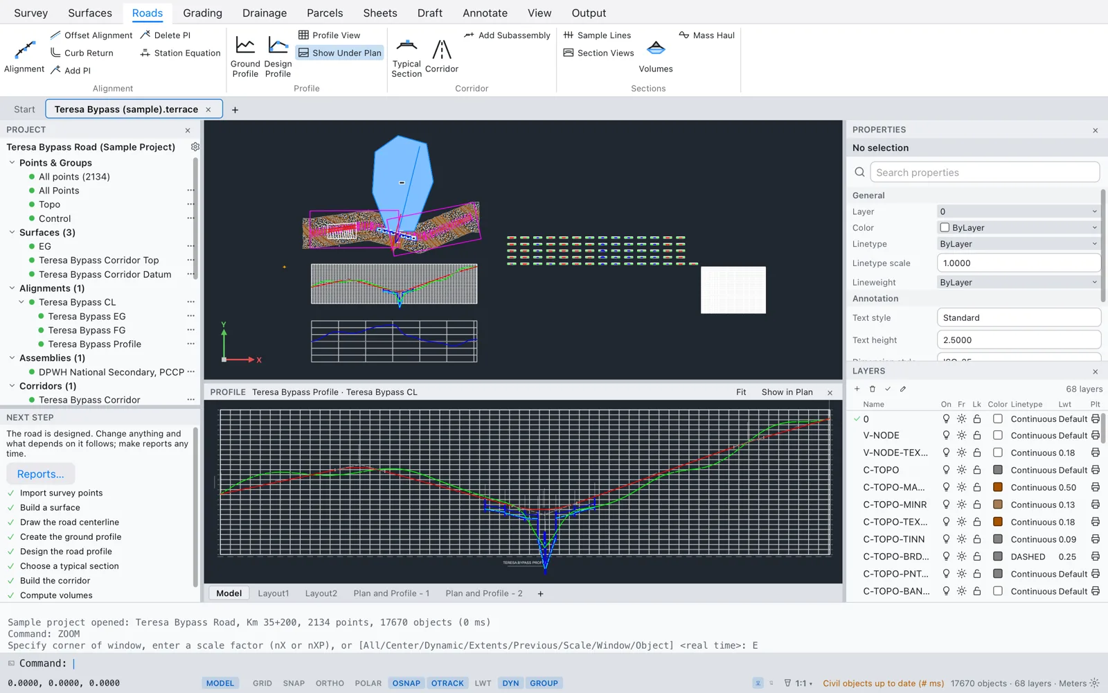
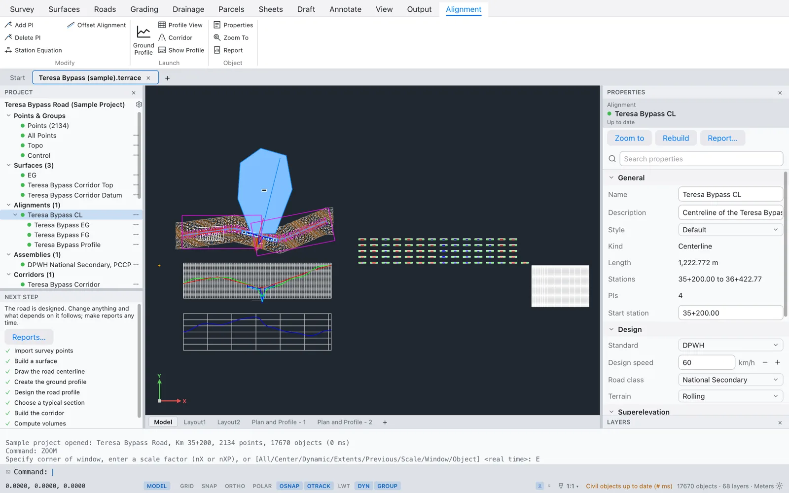
Terrace with the Teresa Bypass sample project open: the Project browser on the left listing points, surfaces, the alignment with its profiles, the typical section and the corridor; the plan in the middle with the survey, the corridor, a catchment, the profile view and section views; and the alignment's properties on the right: DPWH standard, 60 km/h, National Secondary road in rolling terrain
Easier than the usual way

Four things that make it quicker

The tools a civil engineer expects, arranged around the job instead of the software.

1

Change it, and what depends on it follows

Drag a PI and the alignment is solved again, the ground profile is resampled, the corridor and its surfaces are rebuilt, and the cut and fill are recomputed — on a 2 km road over a 50,000-point ground surface, in about a tenth of a second.

The profile of the road you're working on sits right under the plan.

The plan of the sample road with its profile view shown under it: the existing ground line, the design profile with vertical curves, and the storm drain and cross drain in profile
2

The next step, always in view

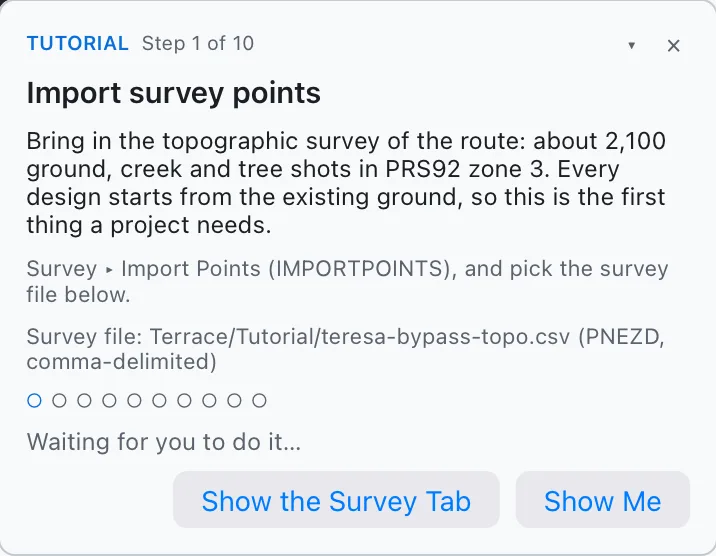
A Next step panel reads the project and offers what to do next — import the survey, build the surface, draw the centerline, design the profile, choose the typical section, build the corridor, compute volumes, make the sheets — each one a button, with a sentence on why.

Problems read in plain words, like “Curve near 0+202.17: radius below the minimum for 60 km/h”, with a button that zooms to them.

The built-in tutorial's card at step 1 of 10, Import survey points: what to do and why, where the button is, and Show the Survey Tab and Show Me buttons
3

Find anything with ⌘K

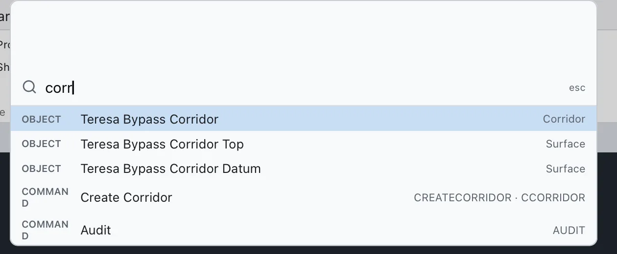
Every command, every object in the project and every report, by name. Type “corr” to jump to the corridor, its surfaces or the command that makes one.

The command line is still there, with AutoCAD-style commands and short aliases, and every step can be taken back from a visual undo history.

The command palette with “corr” typed: the Teresa Bypass Corridor and its Top and Datum surfaces as objects, and the Create Corridor command
4

Reports in one click

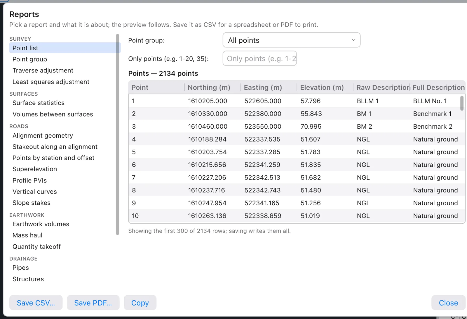
Point lists, traverse and least-squares adjustments, alignment geometry, stakeout, superelevation, vertical curves, slope stakes, earthwork, mass haul, DPWH pay-item takeoff, pipes and structures, lot data and technical descriptions — previewed as you choose, then saved as CSV or PDF.

The Reports dialog: report kinds grouped under Survey, Surfaces, Roads, Earthwork and Drainage, a Point list preview of 2,134 points with northing, easting, elevation and descriptions, and Save CSV, Save PDF and Copy buttons
Survey to sheets

What Terrace does

Survey

COGO points, point groups and description keys; point files and total-station raw files (RW5, SDR33, Leica GSI); traverse adjustment by compass, transit, Crandall or least squares, and least-squares networks with error ellipses; PRS92, Luzon 1911 and UTM coordinates.

Surfaces

TIN surfaces from points, breaklines, contours and boundaries, with edits; grid surfaces from elevation models and point clouds; contours, elevation and slope banding, watersheds, and exact volumes between surfaces.

Roads

Alignments with spiral curves, superelevation and station equations; ground and design profiles with K values checked against the standard; typical sections from DPWH road classes; corridors with daylighting, intersections and finished-grade surfaces.

Earthwork

Sample lines and cross sections, cut and fill by average end area or prismoidal formula, mass haul with free haul and overhaul, and a quantity takeoff by DPWH pay item.

Grading and drainage

Feature lines, pads graded to the ground with balanced cut and fill; storm and sanitary networks designed by the rational method with PAGASA rainfall, HEC-22 hydraulic grade lines, catchments; water mains analysed like EPANET.

Parcels and sheets

Lots, right of way and subdivision, with Philippine technical descriptions (“N. 08 deg. 14' W., 34.19 m. to point 2”); view frames, plan-and-profile and cross-section sheets on A1 or the 20×30 plan sheet.

Files

Open in, open out

FormatReadWriteNotes
Terrace project (.terrace)✓✓The whole design. Renamed to .dxf, it opens as a drawing in any CAD program.
LandXML 1.0–1.2✓✓Points, surfaces, alignments, profiles, cross sections, pipe networks and parcels, tested with files from the common civil design programs. Written files pass the LandXML schema.
DWG and DXF✓✓From Draftwork, Terrace's drafting side: the design is written as ordinary drawing.
Point files (CSV, TXT)✓✓PNEZD and other column orders, detected from the file.
Total station raw (RW5, SDR33, GSI)✓Reduced to points; traverses and networks adjusted.
LAS and LAZ point clouds✓LASGround points thinned into a surface.
GeoTIFF and ASCII grid✓✓Elevation models as grid surfaces.
Shapefile, GeoJSON, KML/KMZ✓✓Transformed to the project's coordinate system.
PDF and CSV✓Sheets and reports.
Under the hood

Built from scratch, checked against the books

Written in Tessel

Terrace is written entirely in Tessel: triangulation, spirals, corridors, hydraulics, LandXML, point clouds and the whole window, with no other engine inside.

Checked, not guessed

About 16,800 tests compare Terrace with published worked examples and independent tools: the AASHTO Green Book and DPWH design tables, Ghilani and Wolf's surveying texts, FHWA HEC-22, EPANET, SciPy, pyproj and laspy.

Fast where it counts

100,000 survey points triangulate in under a tenth of a second, a million in under a second. A 2 km corridor builds in about 35 ms, and a PI drag updates the whole road in about 70 ms.

Terrace Pro

More for the design office

Terrace is free. Terrace Pro adds the DPWH cost estimate and program of works, the DPWH plan set and DED report with your firm's name on them, intersections and roundabouts, turning paths, profile optimisation, a 3D drive-through, culverts, ponds, flood maps and water network analysis, geoid heights and site calibration, point clouds, and IFC 4.3 — for US$199 a year.

Download

Get Terrace

Free to download and use, and it keeps itself up to date. Start with Open the Sample Project — a national road in Teresa, Rizal, with everything built — or the built-in tutorial.

Mac

Open the installer and Terrace goes in your Applications folder.

Download Terrace 0.2.0 for Mac

A Mac with Apple silicon (M1 or later), macOS 11 or later.

Windows

Run the installer: Terrace goes in your Start menu, with an uninstaller. No administrator rights needed.

Download Terrace 0.2.1 for Windows

64-bit Windows 10 or 11.

On Windows you'll see a warning. Terrace for Windows isn't code-signed yet, so the first time you run it, Windows SmartScreen says it's from an unknown publisher. Click More info, then Run anyway.